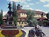
KRKONOŠE SEVERNÍ MORAVA A SLEZSKO STŘEDNÍ MORAVA JIŽNÍ MORAVA VYSOČINA VÝCHODNÍ ČECHY ČESKÝ RÁJ ČESKÝ SEVER SEVEROZÁPADNÍ ČECHY ZÁPADOČESKÉ LÁZNĚ PLZEŇSKO ŠUMAVA JIŽNÍ ČECHY PRAHA OKOLÍ PRAHY PO RUSSKIPOLSKIFRANCAISDEUTSCHENGLISHČESKY
STŘEDNÍ ČECHY - SEVEROVÝCHOD - POLABÍ
  Road accessibility
Information centres
Towns and municipalities
Notable personality
 
NATURE AND ITS PROTECTION
  CHKO KOKOŘÍNSKO
Protected landscape areas
Natural points of interest
Vrcholy, hřebeny, sedla
Fauna a flora
Nature trails
 
CULTUR, ENTERTAINMENT, SPORT
  Culture and entertainment
Sport and relaxation
Zimní sporty
Katalog KUDY Z NUDY
Active holiday
 
SIGHTS AND ATTRACTIONS
  Sights and architecture
Ecclesiastical monuments
Castles and chateaux
 
TOURISM AND LEISURE TIME
  Rural tourism
Hiking
Cycling tourism
Water tourism and sports
Wine tourism
 
BALNEOLOGY
  Spas
Lázeňské domy a sanatoria
Medical cures
Natural medical sources
 
CONGRESS TOURISM
  Exhibitions and exhibition grounds
Congress centres
Exhibitions and promotion
 
ACCOMMODATION & DINING
  Car-camping, camping site
Hotels, Boarding houses
Chaty a chalupy
Recreation areas
Further accommodation
Restaurants
Příjemné posezení
Gastronomic specialities
 
Království perníku

Palkovice [ Village or Town/City ]

Palkovice locality consists of two parts - Palkovice and Myslík. It is situated in the foothills of the Beskydy mountains in the Frýdek-Místek district. The centre of Palkovice has the height of 332 m above the sea level and the highest points are the Kubánkov (662 m above the sea level) and Kozlovická hůrka (612 m above the sea level). The western part of the locality is bounded by the Palkovické Hůrky mountain range (over 500 m above the sea level), where in 1969 the National nature preserve was established with the area of 18,33 hectares and a unique sample of basic vegetation and herbs. The Olešná river flows through the locality. At the beginning of the sixties a recreation dam was built up on the river with the area about 86 hectares. There is also a running track in Palkovice with an artificial lighting and a possibility of creating an artificial snow. Beautiful surrounding nature and the proximity of the Olešná dam offer numerous sporting and tourist possibilities.

Plní funkci základního stupně územní samosprávy a v různé míře je také vykonavatelem státní správy.

PŮSOBÍ NA KATASTRÁLNÍM ÚZEMÍ:

NEXT LINKS

LOCATION

ukázat na mapě

Other objects within a radius of

LAST MODIFY: Šormová Helena (INFOSYSTEM s.r.o.) org. 56, 27.09.2021 v 22:04 hodin
Copyright 1998-2025 © www.infoSystem.cz,
součást prezentačního a rezervačního systému Doménová koule ®
SEARCH
  Search centre
Rejstřík oblasti
Action databank
 
REGIONY A OBLASTI ČR
  Tourist regions ČR
Turistické oblasti ČR
Picturesque regions
 
ZPRÁVY A AKTUALITY
  Tiskové zprávy
 
SLUŽBY PRO TURISTY
  Information centres
Tourist guide services
Tlumočníci a překladatelé
Bankovní služby
Turistický produkt
 
KALENDÁŘ AKCÍ OBLASTI
  Akce pro děti
Kino, divadlo, výstavy
Folk activities and festivals
Tourist activities
Kalendář kongresů a konferencí
Kalendář veletrhů a výstav
 
FOLKLORE AND TRADITIONS
  Etnografický region
Etnografický subregion
Folk associations
Folk ensembles
Folk festivals
Folk traditions and customs
Folk craft and products
 
KLUB ČESKYCH TURISTŮ
  Krajská oblast KČT
Odbor KČT
Turistické odznaky a známky
 
REGIONÁLNÍ ROZVOJ
  Regiony a sdružení
Investment opportunities
Průmyslové zóny
Properties for sale
Industrial production
Food production